We’re written a good deal about space tourism in the past, and about the burgeoning private spaceflight industry.
Most notable in the field, of course, is Spaceship Two project headed by designer Burt Rutan and backed by entrepreneur Richard Branson.
But what about the little guy, toiling away in his metaphorical garage in the hope of becoming the Steve Jobs of private space travel?
By day, Morris Jarvis works as an instrumentation and control engineer for Intel Corp.’s newest factory, Fab 32.
By night and on the weekends, he is Arizona’s version of the "Astronaut Farmer," building a vehicle he hopes to launch into space someday.
Jarvis and his 10 partners have built a prototype of a craft that would take everyday people on suborbital flights for a fee. He named the craft Hermes, a Greek god of land travel…
Jarvis is about three years into the latest prototype, a gleaming white craft that resembles a boxy version of the space shuttle and seats four passengers. He works on it in his shop at his east Mesa home.
The problem is that Jarvis needs money to get a workable model off the ground.
He estimates he needs about $100,000 to do glide testing. He then would need $1.5 million to launch the craft with a helium balloon, the cheaper of two methods he is considering.
Launching the craft with a rocket would take about $5.4 million, he estimates.
Jarvis’ business plan is aimed more at the regular tourist than the wealthy, at least relatively speaking. He hopes space travelers will pay $25,000 — or about the price of a new car — for a trip powered by a helium balloon and $100,000 for a ride powered by a rocket.
That compares to Virgin Galactic, which has already collected $25 million in deposits from would-be space travelers at $200,000 per flight.
But lest you think that Hermes is too much of a garage space project, we should note that Jarvis’ employer, Intel, is building the chip set for the spacecraft.
(Incidentally, Hermes was also the name of a proposed mini-shuttle designed by the French Centre national d’études spatiales (CNES) and the ESA to compete with the space shuttle back in the late 70s and early 80s, according to Wikipedia.)
This is prime time for political junkies. In less than two weeks, the Democratic National Convention kicks off in Denver; one week later, the Republicans hold their party convention in Minneapolis.
But convention broadcasting isn’t what it used to be. Times were, you could watch nearly every night on the Big Three networks; it was a late-summer ritual in presidential election years.
That’s no longer the case, which is why this political junkie is thankful for satellite television.
Dish Network will bring live satellite video feeds into the convention hall from off-site locations across the country. The satellite provider will also offer uninterrupted, unedited live satellite convention coverage to its 13.8 million subscribers across country, available on Channel 211.
In addition, Dish Network’s video feed will be broadcast in HD on television monitors throughout convention venues and will be made available via satellite to television stations for downlink across the country and around the world.
“When we set out to make this convention more inclusive and accessible than ever before, we wanted to do more than get our message out—we wanted to bring the voices of American people into the process, and Dish Network will help us to do just that,” said Brook Colangelo, Director of Technology for the Democratic National Convention Committee, in a prepared statement. “Whether from inside the Convention hall, at watch parties in communities across the country, or from the comfort of their living room, Dish Network’s technology and services will enhance the Convention experience for everyone who’s tuning in.”
What about the Republicans?
Thus far, they’ve only announced that Google will be their "Official Innovation Provider." We’re not sure what that means, exactly, but we’ve got high hopes that a satellite broadcast provider will be announced for the GOP in the coming weeks.
This Thursday, August 14, 2008, an Ariane 5 rocket is scheduled to lift the SES Americom AMC-21 communications satellite into orbit from the European Spaceport in Kourou, French Guiana.
The satellite will operate from the 125 degrees West orbital position after it is launched by Arianespace.
Thales Alenia Space served as the prime contractor and communications payload supplier of the Star-2 spacecraft that was designed, built, integrated and tested by Orbital Sciences Corporation (NYSE: ORB).
AMC-21 was designed and built for advanced telecommunications, mobile applications and TV broadcasting with coverage of the 50 U.S. states, as well as Southern Canada, Mexico, Central America and the Caribbean. Featuring 24 active 36 MHz transponders, the 2500 kg spacecraft has a 15-year design life.
The launch window for AMC-21 is from 5:44 p.m. to 6:35 p.m., local time in Kourou, French Guiana (4:44 p.m. to 5:35 p.m. in New York; or 8:44 p.m. to 9:35 p.m. GMT; or 10:44 p.m. to 11:35 p.m. in Paris; or 5:44 a.m. to 6:35 a.m. in Tokyo, etc.). You’ll also be able to watch the launch on the web here.
Going along for the ride with AMC-21 will be the Superbird-7 satellite for Space Communications Corporation of Japan.
Imagine you’re spending some time on the Galaxy Zoo website — "the project that harnesses the power of the internet and your brain," as the slogan goes "to classify a million galaxies" — and in the image of a remote galaxy that literally no one has ever looked at you find something: different. Something that doesn’t match the classification guidelines given to volunteers on the website.
That’s exactly what Dutch schoolteacher Hanny Van Arkel did when she discovered a green blob in an image that she was classifying on the Galaxy Zoo website. What happened next is incredible.
A new class of cosmic object has been found by a Dutch schoolteacher, through a project which allows the public to take part in astronomy research online.
Hanny Van Arkel, 25, came across the strange gaseous blob while using the Galaxy Zoo website to help classify galaxies in telescope images.
Astronomers subsequently confirmed that the object was one-of-a-kind.
The work has been submitted to the journal Monthly Notices of the Royal Astronomical Society.
The object quickly became known as "Hanny’s Voorwerp" – Voorwerp being the Dutch word for "object".
Researchers think this green blob got its energy from light emitted by a quasar (a powerful radiation source powered by a supermassive black hole) that has since gone dim.
They think the quasar was hosted in a nearby spiral galaxy called IC 2497. It was so bright that, if the quasar was still active, it would be visible from Earth with binoculars.
However, because of the distance between the galaxy and the Voorwerp, light from the quasar would have taken tens of thousands of years to reach the gaseous blob…
Dr Lintott said the object was the only one of its type known to astronomers, though other Voorwerpen could still be awaiting identification.
He added that the object had been catalogued before, but its significance had only been recognised when it was brought to the attention of Galaxy Zoo team members by Ms Van Arkel.
During the last year, 50 million classifications of galaxies have been submitted on one million objects at galaxyzoo.org by more than 150,000 amateur astronomers from all over the world.
The next stage of the project will ask volunteers for more detailed classifications, making it easier to identify more unusual objects such as Hanny’s Voorwerp, according to the BBC report.
No, not those games, though we do confess to being fascinated by China’s attempts to mitigate — or at least conceal — its pollution problem as the opening days of the Beijing Olympics approach.
The games we’re talking about are the Commando Olympics in Afghanistan. Defense Industry Daily has a good roundup of the competition that sends our little rocket scientist hearts a-thumping with excitement: the competition between micro portable Unmanned Aerial Vehicles (UAV).
Getting the gold is the U.S. military’s RQ-11 Raven:
The Raven is a 4.2-pound, backpackable, hand-launched sensor platform that provides day and night, real-time video imagery for “over the hill” and “around the corner” reconnaissance, surveillance and target acquisition. Each Raven system typically consists of 3 aircraft, a ground control station, system spares, and related services.
As a measure of its success, The 3,000th RQ-11A Raven vehicle rolled of the production line back in March 2006. U.S. armed forces use Ravens extensively for missions such as base security, route reconnaissance, mission planning and force protection. According to the U.S. Army, Ravens were flown for approximately 150,000 combat hours in 2007.
DID notes that th e Raven is "ideal for quick peeks to see what’s on the other side of obstructed terrain – like a city block in Iraq, or Afghanistan’s hills and mountains." It’s small and unobtrusive — weighing just over 4 pounds, and with a wingspan of just over 4 feet — and has a low noise signature, making it ideal for use by small special forces teams.
Furthermore, the Raven is "so simple to operate that one of the best pilots in the Iraqi theater was a cook."
But the Raven is not the only mini-UAV in use by special forces around the world: the British have the hand-launched BUSTER (Backpack Unmanned Surveillance Targeting and Enhanced Reconnaissance), the Australians have the Elbit Skylark, and the French have the EADS DRAC Tracker.
Russian aviation firms are taking advantage of cheaper and more reliable new technology to create mini-UAVs for their police and special operations (commando) forces. One such device was recently demonstrated. It was a miniature helicopter, weighing less than 30 pounds, and capable of staying aloft for two hours at a time. Day and night video cameras were carried, and zoom capability was demonstrated. The Unmanned Systems UAV used a laptop based controller. The mini-chopper had a cruising speed of 50 kilometers an hour and a max altitude of 2,000 meters (out of range of most rifles and machine-guns). The helicopter can operate up to 40 kilometers from its base station.
How far can these little birds fly? Last November, a hydrogen fuel-cell powered micro UAV, the Pterosoar, set a new distance record for craft of its type while only using a quarter of its available fuel.
The Pterosoar flew 78 miles, beating the previous record of 50 miles set in Estonia last year. Since it – consumed only 16 of the 64 grams grams of Hydrogen stored on board in a pressurized hydrogen tank, the aircraft has a potential flight range of 310 miles.
The satellite industry is getting exciting again, says Scott Greczkowski over at MultiChannel News:
On Monday DirecTV announced that by the end of the year they would be carrying 130 national HD channels and would also be offering 1080p HD moves by the end of the year.
This morning Dish Network played a game of leapfrog with DirecTV by announcing that by the end of the year they will have 150 HD channels and in addition they will be offering customers full 1080p movies in August….
Dish Network will beat DirecTV to the 1080p race by offering their customers the movies “I am Legend” in 1080 and I am told the quality will be comparable to Blu-ray. Dish Network surprised me by announcing all of it’s MPEG4 HD DVR’s would be upgraded (or “Turbo Charged”) via a software download in August to be able to display 1080p. I personally thought that in order to see these resolutions a customer would need a new receiver such as the upcoming Dish Network 722k MPEG4 HD DVR that will be available to customers later this year. This surprise announcement shows me how well thought out the Dish Network receivers really are, as I never expected them to be able to support 1080p resolutions.
In addition, the direct-broadcast satellite operator is debuting TurboHD, three all-HD programming packages. The three TurboHD tiers are: Bronze ($24.99/month for more than 40 channels), Silver ($32.99/month for more than 50 channels) and Gold ($39.99/month for more than 55 HD channels).
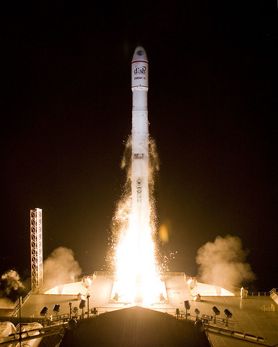
Dish said it has the capacity to offer up to 150 HD channels with the July 16 launch of its Echo XI satellite, which Rocco blogged about here.
"XM Canada is in a strong strategic position to maximize any opportunities that arise for the enhanced benefit of our shareholders and customers," said Michael Moskowitz, President and CEO of XM Canada. "We are now evaluating how best to leverage the FCC’s decision so that we optimize our critical, market-leading advantages, which include innovative partnerships, long-term automotive contracts, steadily increasing retail market share, superior signal coverage and 130 channels of unbeatable programming. Our aggressive growth strategy is delivering improved financial performance and we are committed to providing the best service possible to our subscribers."
XM Canada has an exclusive Canadian license from U.S.-based XM Satellite Radio.
Meanwhile, the Canadian satellite operators are expanding. First, the upstart Ciel recently announced that Industry Canada has issued them "Approvals in Principle" to develop the following spectrum: Ka FSS at 91°W and 109.2°W; 17 GHz BSS at 91°W, 103°W and 107.3°W; and 12 GHz BSS at 138°W.
Second, Telesat has issued a "call for interest" from broadcast, enterprise and government customers who might wish to jump on board Telesat’s recent acquisition of six satellite approvals-in-principle for development of BSS and FSS frequencies from Industry Canada.
Is the rapid expansion of orbital locations to the north too much? Time will tell. DirecTV and DISH Network, for example, are in need of more bandwidth for HDTV expansion. Whoever "bags an elephant" as big as those companies will surely find their investments paying off.
Speaking of Canadian elephants, there’s a nice elephant statue in St. Thomas, Ontario:
Finally — and completing our roundup of Candadian space news — a tiny Canadian satellite will be looking for a different kind of "elephant" — giant asteroids:
The last time it happened, many scientists say, it killed off 70 per cent of all life on the planet and wiped out the dinosaurs.
But the next time some city-sized chunk of rock comes shooting through space toward the Earth, a team of scientists led by a Canadian intend to find out in time to stop it.
A one-of-a-kind, $12-million satellite mission to be launched by the Canadian Space Agency in 2010 will track at least some of the tens of thousands of large asteroids within striking distance of Earth.
The satellite, called the Near Earth Object Surveillance Satellite (NEOSSat), will give researchers a whole new view of space. Instead of looking for asteroids with large telescopes in observatories, researchers will get to see the skies from the point of view of the satellite — 24-7 data from areas not normally visible from earthbound telescopes.
The satellite, designed to be more controllable than the Hubble Space Telescope, will be able to twist and move in space, giving researchers an unprecedented range of view while tracking moving bodies.
The spacecraft that may end up saving all of life on earth is being built by Ontario-based Dynacon.
Longtime DIY Friday fans may remember that we’ve provided plans for an at-home weather station before.
So are we repeating ourselves? Running out of ideas? Not really. The previous DIY Friday weather project was pretty sophisticated, relying on a satellite tracker, antenna, and PC-controlled receiver to deliver the forecast to you.
But the folks over at Expert Village have put together a nice video series (aimed at kids) on How to Predict the Weather. Here’s the first episode:
The series inspired us to track down some good family-friendly DIY weather projects. After all, it’s almost August — time to make some memories (not to mention barometers) with the kids before they get back into school.
There are two places we recommend starting.
Disney’s Family Fun has a good set of DIY instructions on building your own weather station, suitable for kids age 6-12:
Making instruments for a weather station is a great rainy day activity. Weather is on the mind of any kid trapped indoors on a summer day: A rain gauge can be put to immediate use and a barometer is best set up when air pressure is low. To hold everyone’s interest over the long run, you and your kids can set up a weather station and update it each day for a couple of weeks or you can visit the station when big weather happenings are in store….
A basic station starts with a wind vane, barometer, rain gauge, and a maximum/minimum thermometer. If you want a deluxe weather station you can add an anemometer to measure wind speed, a nephoscope to track cloud movement, and a psychrometer to measure relative humidity (directions are in most kids’ weather books).
All of the devices can be built with simple household tools and easily-acquired materials; the barometer, for example, requires a clear, straight-neck glass bottle, a clear glass jar, some food coloring, and a rubber band.
In other words, even the clumsiest mom and dad can lead their brilliant kids through this project. Or vice versa, as the case often is.
Also check out Franklin’s Forecast for another family-friendly guide to building your weather station.
So check the forecast, find a rainy day, get your tools and materials together — and enjoy a day with the kids. We predict that you’ll have fun.
Posted in Front Page | Comments Off on DIY Friday: Build Your Own Weather Station
Here’s a question. When a major natural disaster strikes — for example, in Myanmar (Burma) earlier this year — how does the world figure out how many people are affected?
Here’s the answer: they ask SEDAC — NASA’s Socioeconomic Data and Applications Center — which works with GRUMP.
No, not that GRUMP; the Global Rural-Urban Mapping Project (GRUMP) provides estimates of the population of the world and population densities, which are then overlayed with other scientific data to provide detailed maps of everything from ecosystem assessments to — wait for it — the global poultry density.
And, of course, the number of people affected when disaster strikes:
“The gridded population product we produce helps officials understand the density of the population in and around a disaster area,” said Robert Chen, manager of NASA’s Socioeconomic Data and Applications Center (SEDAC) and director of the Center for International Earth Science Information Network (CIESIN), part of the Earth Institute at Columbia University in New York. “The data set shows where people actually live in relationship to hazardous events….
SEDAC, a part of NASA’s Earth Observing System Data and Information System, collects, stores, processes and distributes population, land use, and socioeconomic data. A significant mission of NASA’s Earth-observing satellite program is to enable scientists and other users to conduct analyses and make decisions based on the resulting data. SEDAC advances this mission by developing and operating practical applications that merge social science and Earth science data to improve knowledge of how humans interact with Earth’s environment.
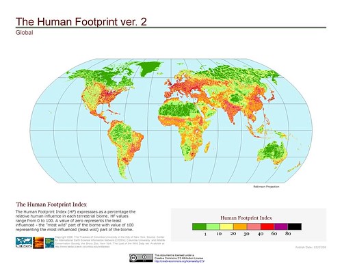
The dataset produced by GRUMP is fascinating. Think you live in a crowded area? Take a look at India and China. SEDAC has also produced an amazing series of maps showing the "human footprint" on the world, which can be viewed here.
Carl von Clausewitz once famously observed that war is the extension of politics by other means.
So it seems fitting, at least in the sense that truisms are true, that the satcom-on-the-go platform that has been bringing the American people live coverage of the presidential election (which we blogged about here) is now being used by U.S. Special Forces in the Middle East.
Now comes a press release announcing that ViaSat Airborne Broadband Ku-band satcom is being deployed by U.S. Special Forces for real time data and video communications:
The system is already in use in the Middle East and coverage areas will expand as more terminals and hubs are delivered. This new operational capability, an extension of the ArcLight® mobile broadband system, is installed on C-130 aircraft, primarily for sending high resolution video back to higher command authorities for further analysis and identification.
Here’s a video of the type of real-world situations that the ArcLight system can help commanders in-field and at the United States Special Operations Command address. It’s taken from an AC-130 Gunship observing insurgents in Iraq. (Warning: Video contains violence and may not be suitable for all viewers.)
The C-130 satcom system is built around the advanced ArcLight modem and networking technology using a spread spectrum waveform to enable the use of mobile satellite antennas as small as 29 centimeters in diameter. The antenna is enclosed in a radome attached to a redesigned emergency escape hatch. In a few minutes, operators can configure an aircraft for their specific mission without any permanent aircraft alterations, then quickly return the aircraft to its normal configuration when the mission is complete, while maintaining safety-of-flight integrity. The U.S. Air Force-certified hatch-mount terminal enables secure access to Department of Defense wide area networks at raw data rates up to 10 Mbps inbound and 512 kbps outbound while airborne.